Depopulation is changing the fire map of Europe
The rural exodus and the climate crisis have transformed Europe's countryside, and with it the fires that affect the continent every summer.

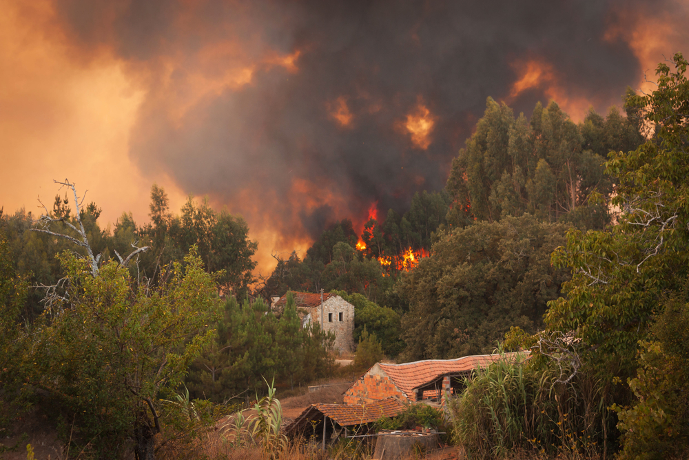
© Paulo M. F. Pires/Shutterstock
Benicarló, Nules and Burriana. This August, in just one week, fires have broken out in all of these municipalities in Castellón. In all three cases, the flames spread through abandoned crops. It is a story of the Levante (the Eastern part of the Iberian peninsula) but also of the whole of Europe: the abandonment of rural areas is leaving millions of hectares at the mercy of nature and, consequently, fire.
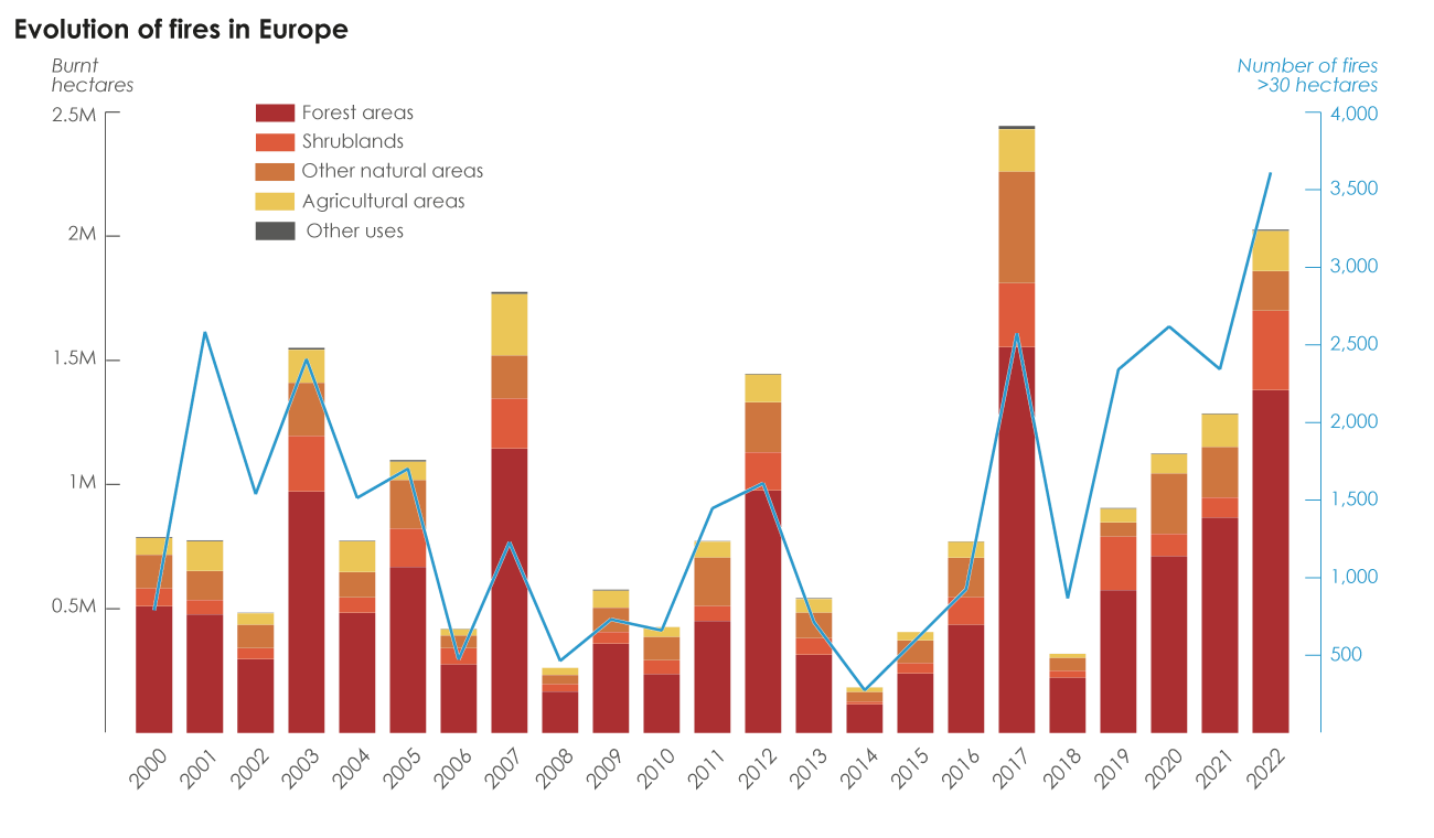
It is not a new threat, but an increasingly dangerous one, as fires are increasing on the continent. It is also not a linear process: the affected areas vary from year to year, with peaks and drops every five years. Major fire seasons produced particularly desolate landscapes in 2003, 2007, 2012, 2017 and 2022, with between 700,000 and 1.2 million hectares burned, areas comparable to Cyprus or Kosovo.
The causes of this increase in fires are complex. Climate change is leading to an increasing number of warm and dry episodes that are increasingly reaching further North, favouring the dryness of the terrain which fans flames. However, there is another key factor: land use change. The Europe of 2022 is very different from the Europe at the beginning of the century, with a major change in landscape and land management that began decades ago but whose consequences we are only seeing now. The current fire map of Europe is, in this sense, an illustration of the rural exodus and abandonment of the countryside.
Every year, the European Forest Fire Information System (EFFIS) detects more and more fires large enough to be seen by satellite sensors, including in the North of the continent, as shown by the large fires in Gävleborg and Jämtland in Sweden in 2018. “Cultural, historical or land management characteristics have changed precipitously in Europe and our vulnerability is greater”, confirms Cristina Montiel, professor of Geography at the Complutense University of Madrid and an expert in forest fires and land management.

Grafico_Europa_incendios_Ingles (1)
Source: EFFIS (2023)
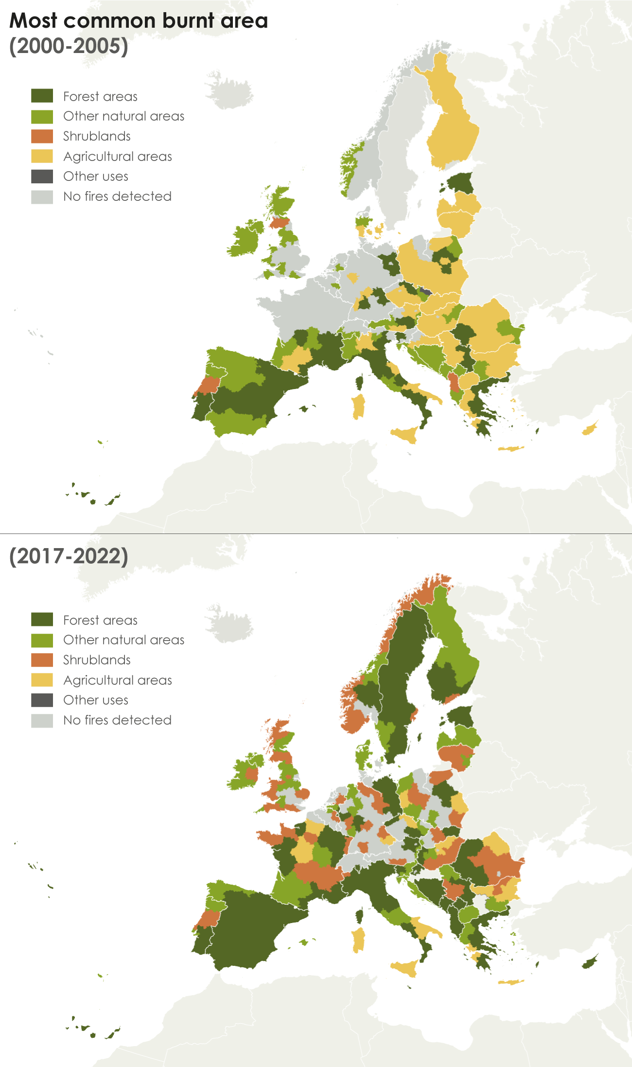
Two decades ago the fire pattern in Europe mainly affected Eastern Europe and its agricultural areas such as crops and grasslands, the South with large fires in a mosaic of forests and other natural areas (grasslands, peatlands, wetlands, etc.), and the Northwest with some scattered outbreaks in non-forest natural areas.
However, in the last two decades, the picture has changed completely. Forest fires are now dominant in most regions of Europe, especially in the South and the Baltic. In Spain, for example, they have increased from 27% of the total burned area in the period 2000-2005 to 42% between 2017 and 2022, and in Finland from 25% to 40%. Meanwhile, much of the crops and pastures that used to burn in the East have been abandoned and the flames are now mostly burning bushland, as in Romania, where agricultural fires have gone from 37% of the burned area to 14% and bush fires from 2% to 42%.
Former croplands and pastures have been reclaimed by nature as the countryside depopulated and aged, and now these once managed areas – grazed, ploughed, cultivated and harvested – are tending to return to their original state, whether in the form of grasslands, wetlands or forests. But it is not a quick process, and in the case of forests it takes several decades. “What burns the most are the unregulated areas, those where there is no defined use and they are in permanent change”, says Professor Cristina Montiel. The lack of control is in fact one of the major problems in the Northwest of the Iberian Peninsula, the region that suffers the most fires in Europe, as El Orden Mundial also explained in this report about eucalyptus-related fires in Galicia.

Depopulation is the main cause of this transformation in land use, but not the only one. Tourism or real estate speculation are also factors to be taken into account, as when projects are found to be unprofitable and subsequently abandoned, the land is too often left to its own devices, opening up new fronts for vegetation to advance and increasing the vulnerability of the territory to fires.
Although with many environmental conditions and regional differences, the map of fires by land use in Europe is also a map of development, especially visible in countries that have changed radically in the last two decades and that now record regular fires. This is the case in Romania, Bulgaria and Hungary. In the richest regions of these countries, where the rural environment has been most transformed, the areas that burn the most tend to be forests, as in Western Romania; scrubland in areas that started to change more recently, as in central and Eastern Romania; and agricultural areas in the less advanced parts, such as the remote Northeast of Romania.
“A very rapid territorial change will translate into an equally rapid change in the risk of fires spreading”, explains Montiel. In the last five years, this pattern has emerged particularly clearly in Italy, where the area burned has doubled compared to the beginning of the century, marked over the North-South divide that is so characteristic of the country. In the rich North, the most burned areas are forests, in the centre other natural areas and in the islands and the less prosperous South, agricultural areas, although there are also anomalies caused by orography, such as the Southern – but mountainous – Campania and Calabria, which are dominated by forest fires.
Fire has traditionally been a landscape management tool in Europe. Controlled stubble burning served to return nutrients to the soil and prevent uncontrolled fires later on. However, this practice has become less common and more dangerous as neighbouring plots have ceased to be cultivated as well. Europe has now shifted to defending itself from flames: from more fires and a longer fire season that reaches further North, and from a change in land use and landscapes that play host to these fires. This presents an adaptive challenge for firefighting teams, who must quickly learn to control fires in hitherto unfamiliar environments.
Methodology
Data on fires has been obtained from EFFIS (European Forest Fire Information System) and land use data from Corine Land Cover, both from the Copernicus programme.
Until 2018 EFFIS was only able to detect fires larger than 30 hectares. The threshold is now reduced to 5 hectares. Furthermore, in all its statistics EFFIS excludes fires that only affect urban or agricultural areas.
To simplify the analysis of the data, fires have been categorised according to the main land use of the burned land. In this sense, the category of “scrubland” used in this article is referred to by EFFIS as “transit”, and refers to usually abandoned and degraded areas covered with undergrowth.
Original source: https://elordenmundial.com/mapas-y-graficos/despoblacion-y-fuego-asi-estan-cambiando-los-incendios-en-europa/
 This material is published in the context of the "FIRE-RES" project co-funded by the European Union (EU). The EU is in no way responsible for the information or views expressed within the framework of the project. Responsibility for the content lies solely with EDJNet. Go to the FIRE-RES page
